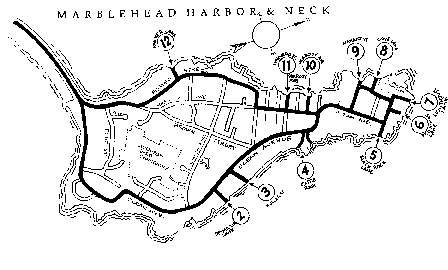
Marblehead Neck's Historic Lanes and Ways:
Public and Private

| 2. Desmoulin Lane: PUBLIC -- Extends easterly from Ocean Avenue in a straight line to low water. The way is 30 feet in width. Walk to the water. 3. Fuller Lane: PUBLIC -- Formerly known as Beach Lane, this way extends northeasterly from Ocean Avenue in a straight line a distance of about 342 feet to land now or formerly of Brackett. The way is 30 feet in width. 4. Castle Rock & Castle Rock Lane: PUBLIC -- Extends southeasterly from Ocean Avenue to low water. Castle Rock Lane is about 25 feet in width at Ocean Avenue. The width remains at about 25 feet for about 111 feet and then fans out to about 415 feet in width at low water. Walk to the water. 5. Black Rock Lane: PRIVATE -- 1994 Town Meeting exchanged the lane for two lots of land at Black Joe's Pond. But this lane formerly extended southeasterly from Ocean Avenue in a straight line a distance of about 108 feet to land now or formerly of Brackett. The lane was 25 feet in width. 6. Point O' Rocks Lane: PUBLIC -- Extends northeasterly from Follett Street in a straight line a distance of about 212 feet to land now or formerly of Brackett. The way is 25 feet in width. 7. Lighthouse Lane: PUBLIC -- Extends northeasterly from Follett Street in a straight line a distance of about 366 feet to low water. The way is 25 feet in width and now forms part of the parking lot at Chandler Hovey Park. Walk to the water. 8. Cove Lane: PUBLIC -- Extends northwesterly from Kimball Street in a straight line a distance of about 223 feet to low water. The way is 20 feet in width. Walk to the water. 9. Nahant Street: PUBLIC -- Extends northwesterly from Ocean Avenue in a straight line a distance of about 670 feet to low water. The way is 20 feet in width. Walk to the water. 10. Peabody Avenue: PUBLIC -- Extends northwesterly from Harbor Avenue in a staight line a distance of about 287 feet to high water. The way is 20 feet in width. Walk to the water's edge. 11. Harvard Street: PUBLIC -- Extends northwesterly from Harbor Avenue in a straight line a distance of about 406 feet to low water. The way is 40 feet in width. Walk to the water. 12. Parker Lane: PUBLIC -- Extends northwesterly from Foster Street in a straight line a distance of about 227 feet to high water. The way is 20 feet in width. Walk to the water's edge. |
Historical note: As a result of litigation, the erroneously named and noted "Fishing Point Lane"
has been removed from our list of Town lanes and ways. It was previously listed as #1 on the map,
but the Appeals court made it clear, that this private driveway never was in accordance with the laws
determining what is and what is not a public or private way.
legendinc.com | Search | Ask | Archives | Online Store | Contact Us
Ad Info | Employment | Courier Pages | Marblehead Magazine
Stuff of the Day